Exploration Portfolio
Our Projects
Two flagship projects with active drill permits in two of Canada's most prospective gold-mining jurisdictions — the high-grade Gold Bridge camp of British Columbia and the Archean greenstone belts of Nunavut.
District Context
In the Heart of a Major Mining Camp
Bathurst Metals' projects sit alongside multi-million-ounce gold districts — each home to producers and well-financed peers actively unlocking value in proven geological belts.
Gold Bridge Mining Camp
~17.7 g/t Au
Canada's highest-grade historic gold district. Peers: Talisker Resources (TSK.V ~$300M) — Bralorne Mine 1.7 Moz @ 6.4 g/t. Endurance Gold (EDG.V ~$100M) — Reliance Project 1.45 Moz @ 2.3 g/t inferred.
Hope Bay Gold District
3.4 Moz @ 6.53 g/t Au P&P
Agnico Eagle. 2.2 Moz @ 4.61 g/t Au indicated; 3.2 Moz @ 5.98 g/t Au inferred. Same Archean greenstone belt as Turner Lake.
Goose & Back River District
Goose Mine — 300 koz/yr @ 5.97 g/t
B2Gold. 2.4 Moz @ 6.79 g/t Au P&P; 4.2 Moz @ 7.45 g/t Au Indicated; 3.5 Moz @ 8.05 g/t Au inferred.
* Reserve and resource data from Agnico Eagle, B2Gold, Talisker Resources, and Endurance Gold corporate websites (May 2026).
British Columbia — Gold Bridge Camp
Peerless Project
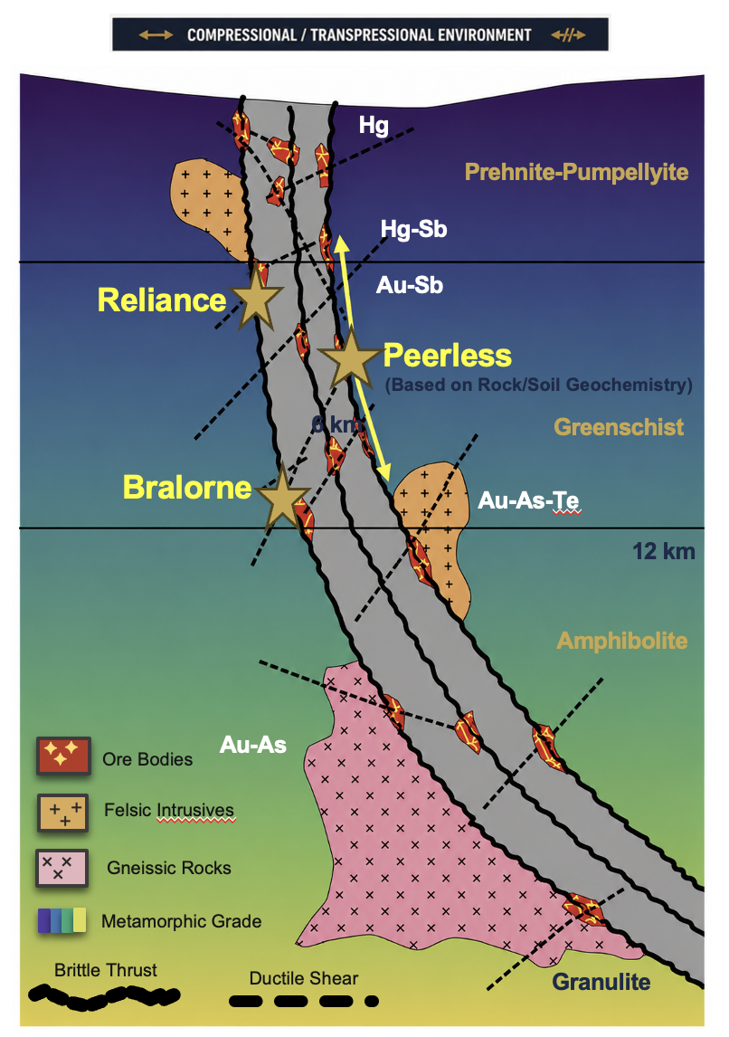
An intermediate orogenic gold system bridging the Bralorne and Reliance styles in Canada's highest-grade historic gold district — a compelling and underexplored target with an active drill permit.
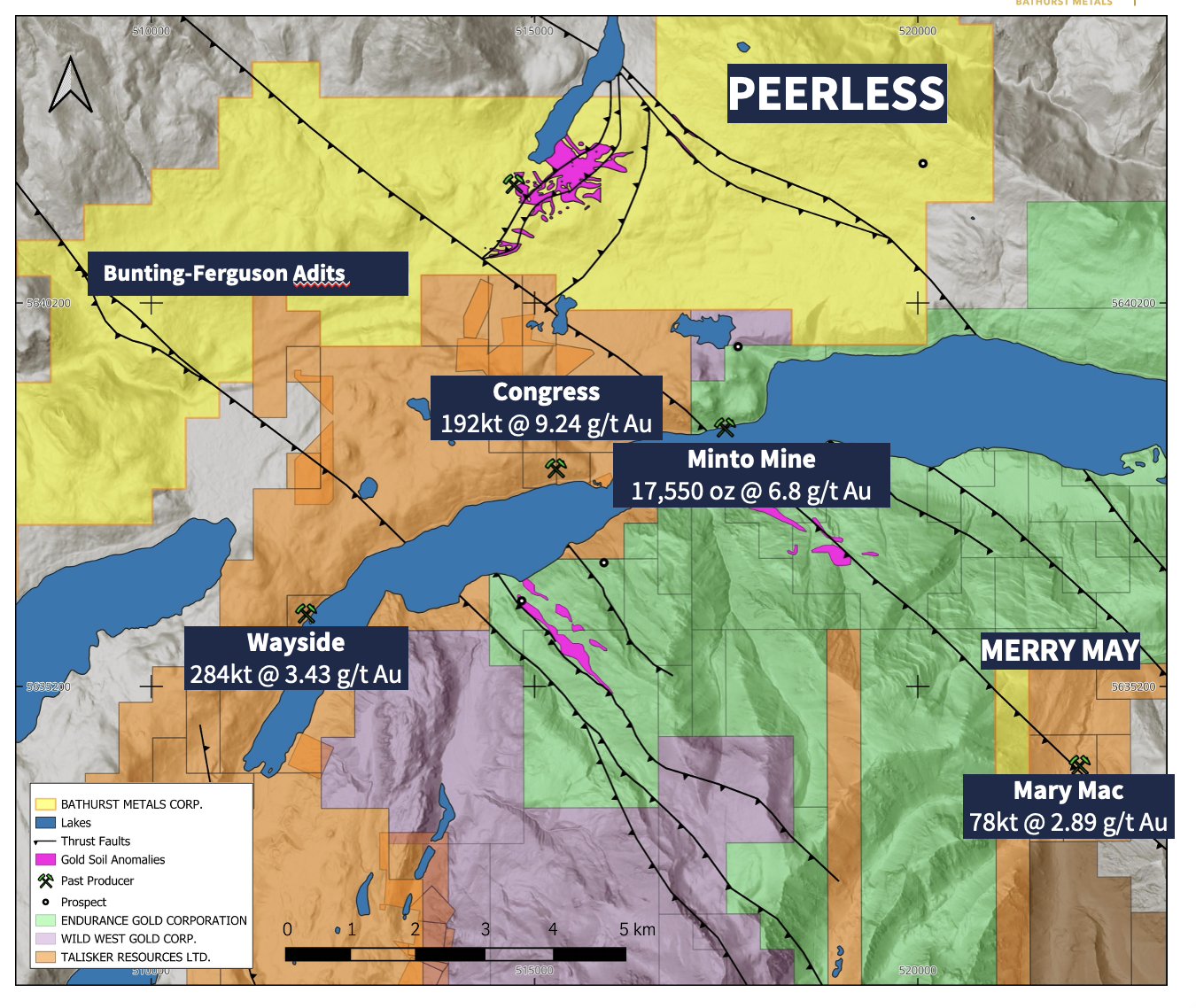
Bathurst Metals claims (yellow) and surrounding gold occurrences in the Gold Bridge Camp, British Columbia.
Key Differentiator
Large-scale Au, Ag, Pb, Zn anomalies over a 1,500m × 600m corridor where thrust faults are crosscut by shear structures — the classic structural setting for high-grade orogenic gold.
Property Highlights
- ▸ Same geological setting as surrounding historical mines & deposits
- ▸ Historical underground workings with known gold occurrences
- ▸ Multi-ounce high-grade drill intercepts (historical)
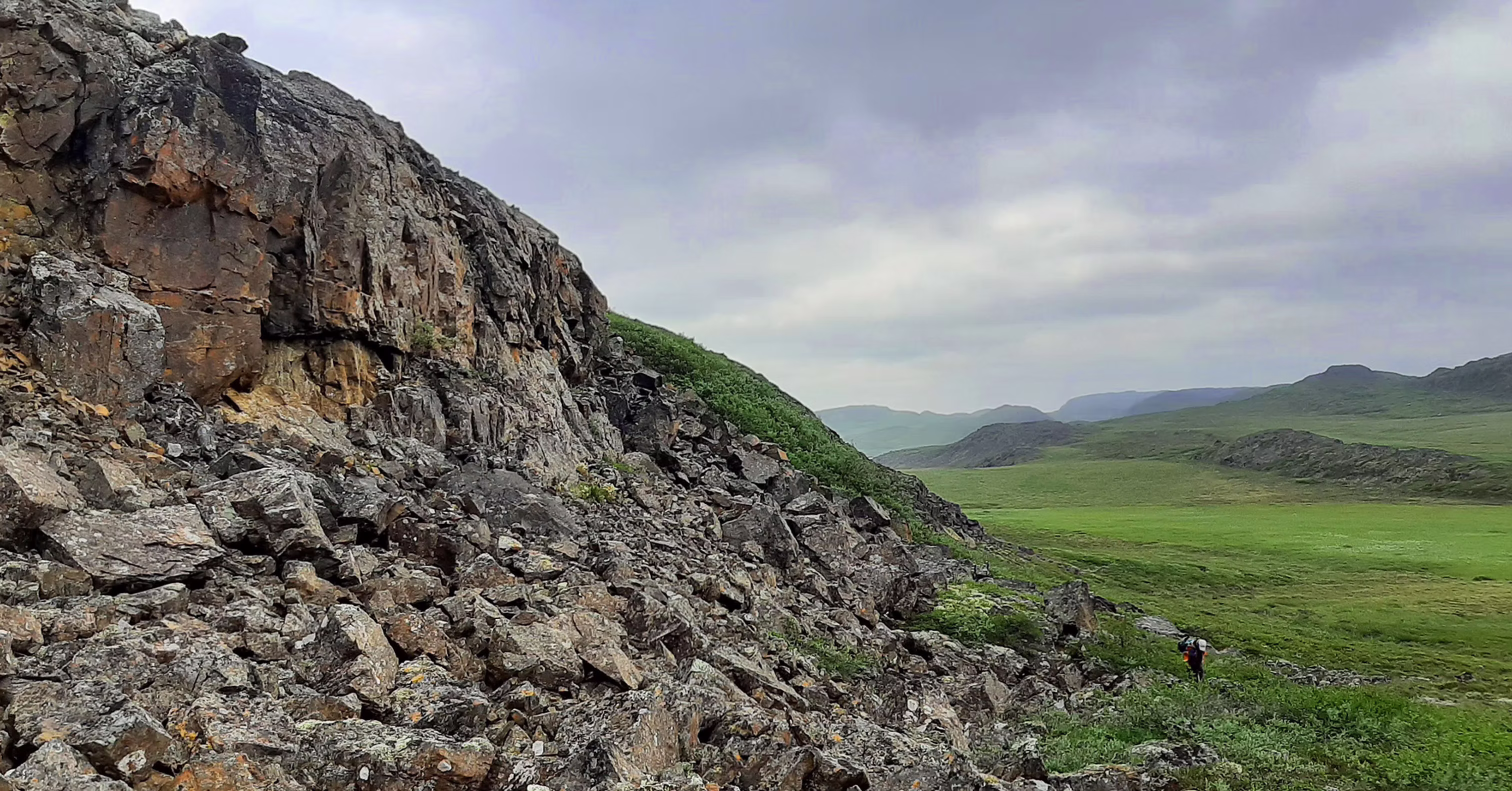
- ▸ Accessible year-round; moderate topography
- ▸ Extensive logging road network across property
Deposit Geology
"Peerless represents an intermediate orogenic system bridging the Bralorne and Reliance styles — a compelling and underexplored target."
Five Distinct Gold Zones
Thrust faults and secondary faults cross the anomalous zone — a classic structural setting for orogenic gold mineralization.
Historical Sample Results
| Area | Sample Type | Interval (m) | Grade (g/t Au) |
|---|---|---|---|
| Alpha | Channel Sample | 2.0 | 13.70 |
| Beta | RC 87-8 | 4.52 | 28.93 |
| Beta | RC 87-9 | 1.52 | 35.12 |
| Beta | RC 87-12 | 6.10 | 4.67 |
| Beta | DDH PR24-004 | 5.10 | 6.30 |
| Peerless Zone | Underground Channel | 2.0 | 13.70 |
All sample intervals from drilling are sample lengths, not true widths. Historical results not independently verified.
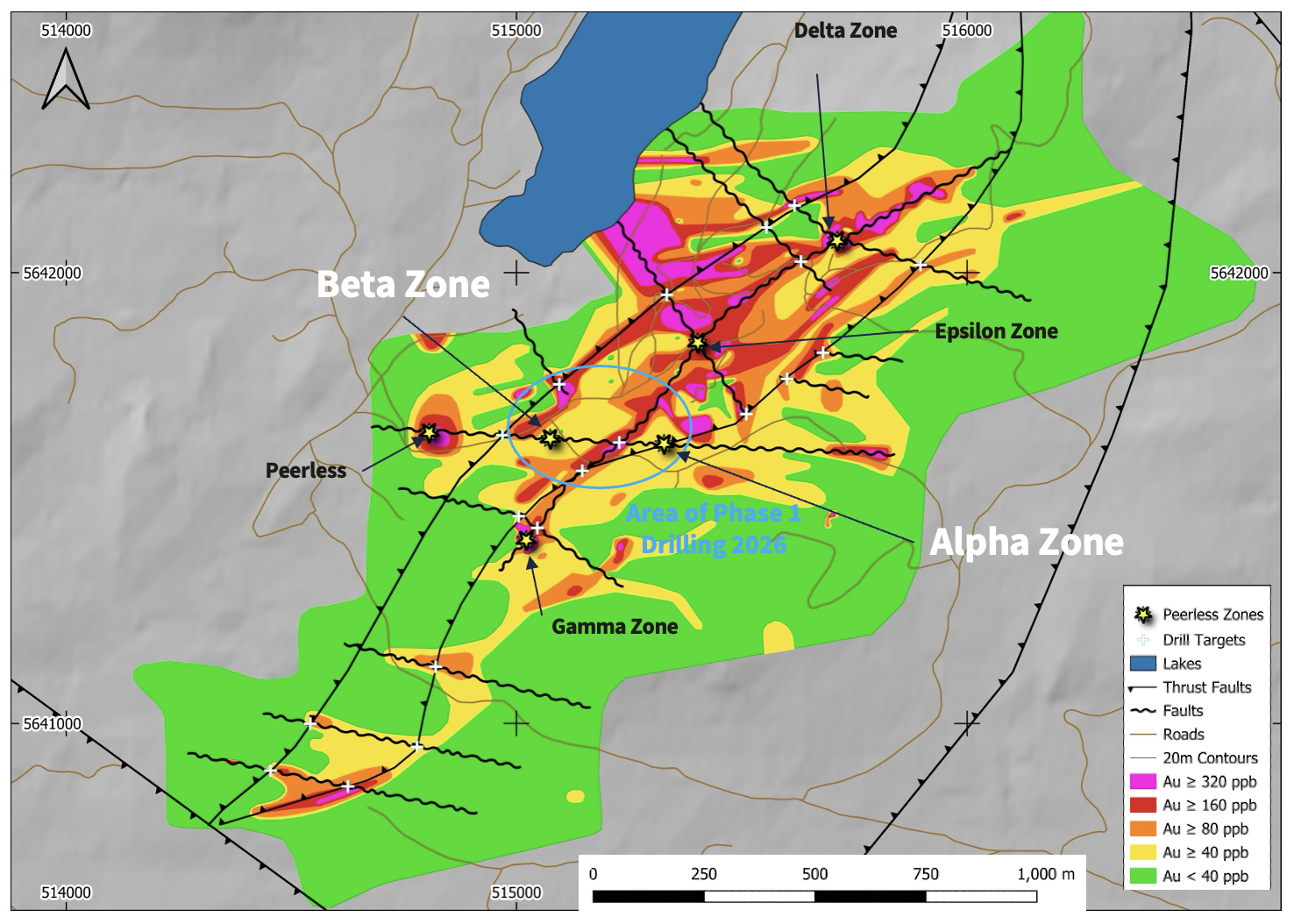
Drilling Program — 2026
Target the intersection of the East-West shear zone and the thrust fault where the 2024 drilling program intercepted visible gold.
Drilling Objective
Test the lateral and down-dip extension of the Alpha and Beta Zones along the brittle thrust fault corridor.
- ▸ Drill targets intersect known gold-bearing structures
- ▸ Visible gold confirmed in 2024 drilling program
- ▸ Subvertical ductile shears within ultramafic host
- ▸ Phase 1 designed to upgrade and expand existing zones
Alpha · Beta
Zones Targeted
2026
Drilling Year
Active
Permit Status
Visible Gold
Prior Result
Target Setting
Ductile shears (subvertical dip) and brittle thrust fault intersect within ultramafic and volcanoclastic units — the proven geometry for high-grade orogenic gold deposits in this district.
Nunavut, Canada — Bathurst Metals Gold Camp
Strategic Land Position
Bathurst Metals controls 100% of all significant gold occurrences in the Turner Lake area — a district-scale gold and polymetallic opportunity with strong discovery potential, located within the same prospective greenstone belt as multi-million-ounce producers.
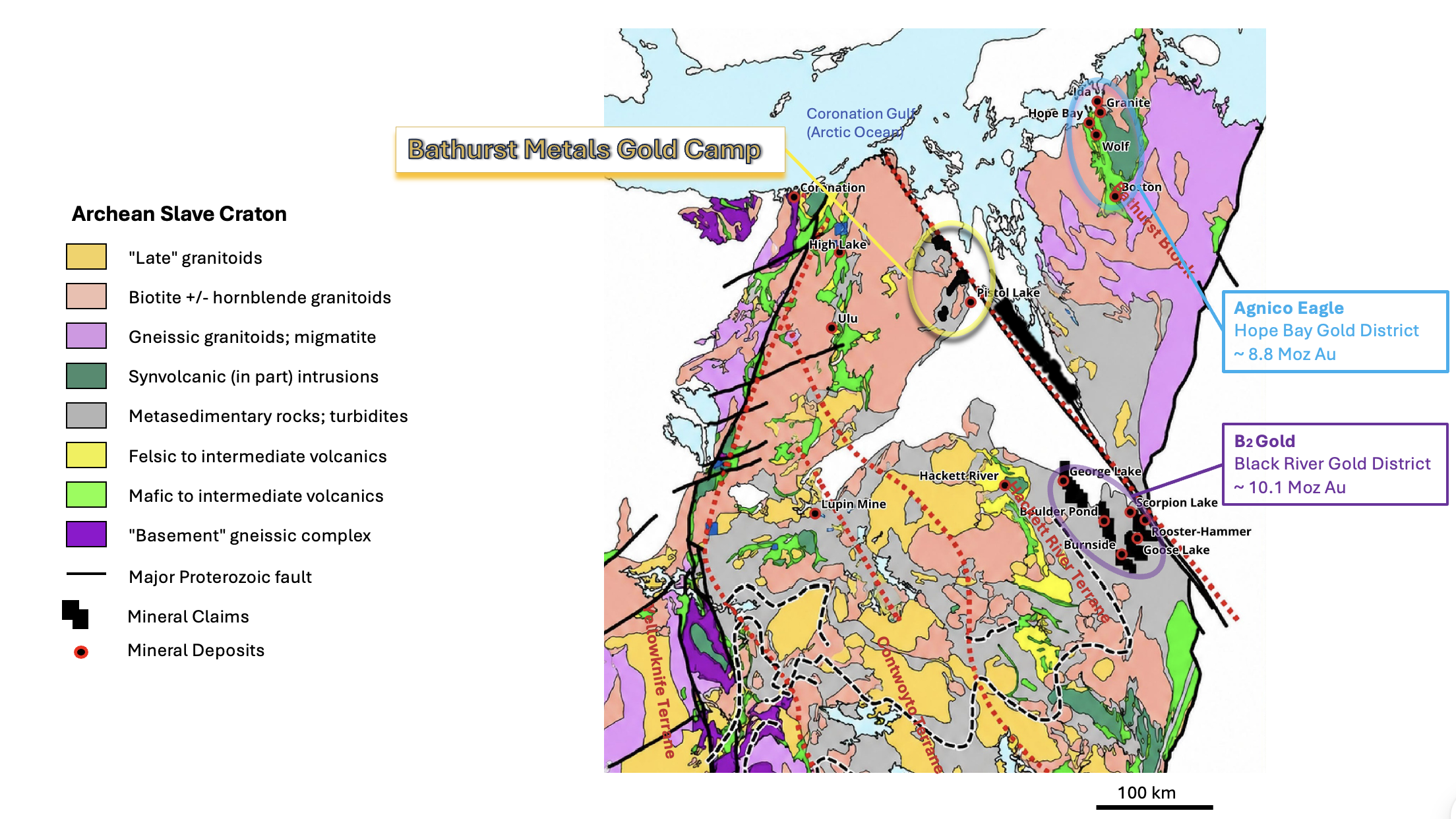
Bathurst Metals land package along the regional Bathurst Fault corridor — Turner Lake, Gela, Gela West, and BIF properties.
Simplified Slave craton geology modified from Bleeker & Hall (2007) and Stubley (2012).
Greenstone Belt Context
Located within the same prospective Archean greenstone belt as two multi-million-ounce producers:
District Strengths
- ▸ Archean amphibolite-facies geology near the 300 km Bathurst Fault
- ▸ Region known to host multi-million-ounce gold deposits
- ▸ Limited modern exploration despite documented occurrences
- ▸ Stable Canadian jurisdiction; First Nation land matters settled
District Portfolio
Turner Lake
FlagshipAu · Ag · Cu · Ni
125 km² · Active Drill Permit
Multiple mineral occurrences. High-grade historical drill intercepts. Open in all directions and to depth.
View detailsGela Lake
100% OwnedCu · Ag · Au
Large-scale greenfields
Large-scale Cu–Ag–Au greenfields target with strong geophysical anomalies. Strong discovery upside.
Gela West
100% OwnedAu
Underexplored
Historical gold values up to 10.30 g/t Au with limited modern exploration completed.
BIF
100% OwnedAu
Underexplored
District-scale land package within the strategic Turner Lake corridor — strong discovery upside.
Nunavut — Flagship Project
Turner Lake / TED Project
An under-explored project in the same prospective greenstone belt setting as Agnico Eagle's Hope Bay (~8.8 Moz) and B2Gold's Goose & Back River District (~10.1 Moz) — with multiple mineral occurrences and high-grade historical drilling.
Direct Evidence
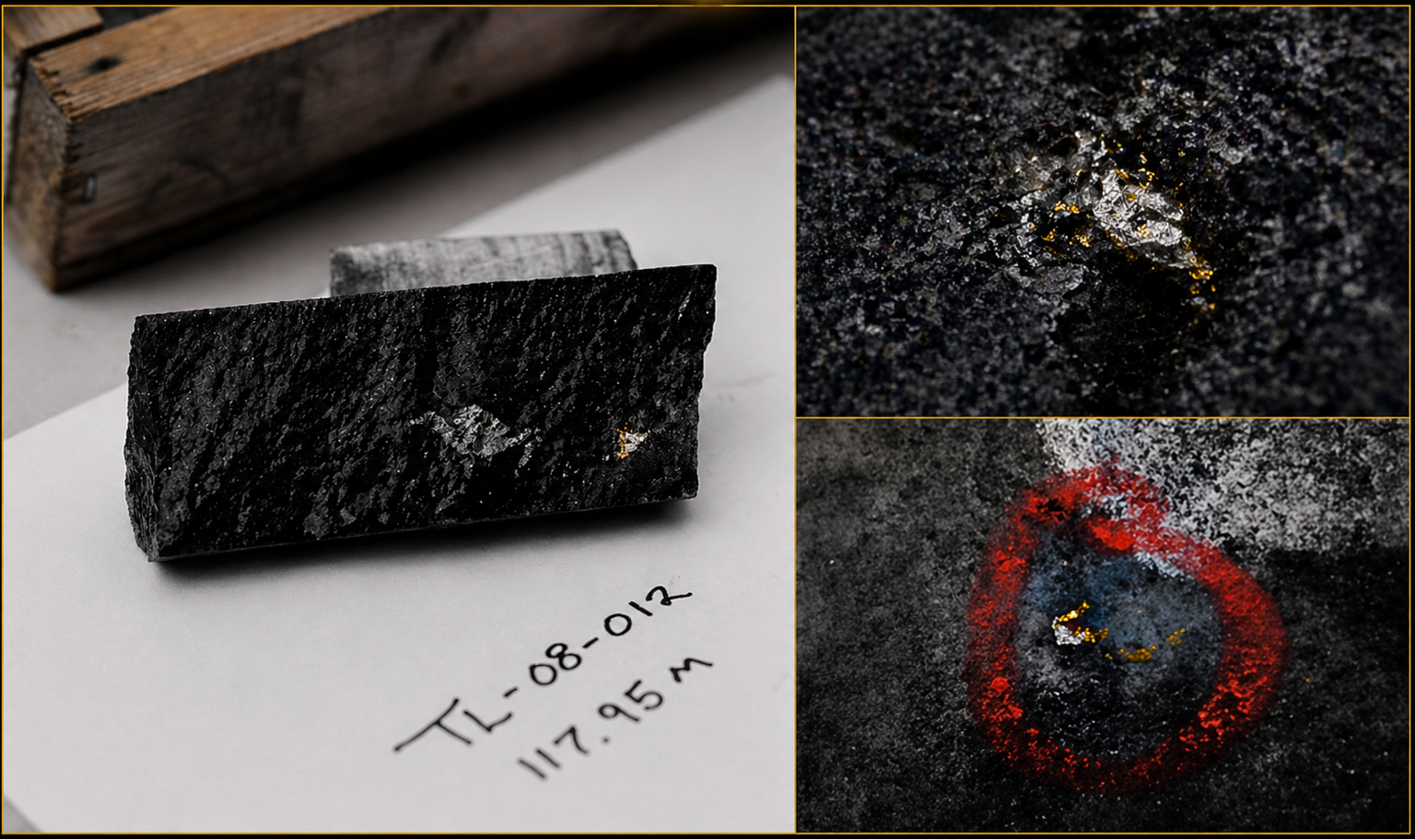
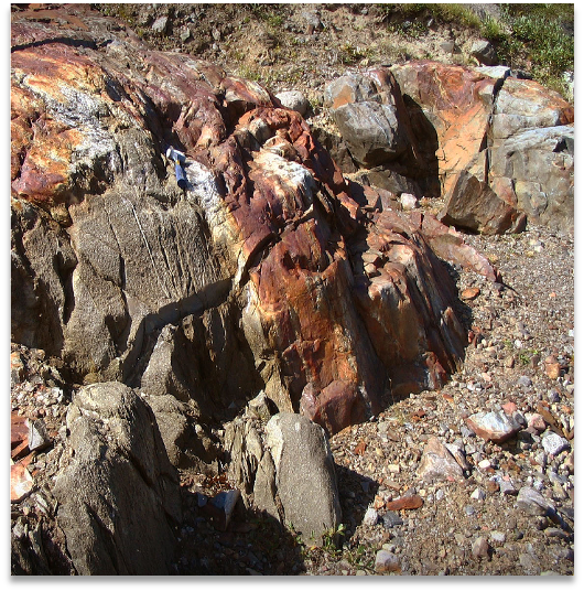
Visible Gold on Surface and in Core
The Turner Lake project has produced visible gold both at surface and in drill core — a direct, tangible indicator of significant gold mineralization at the project.
Drill Core — TL-08-012 at 117.95m
Visible gold logged in drill core, accompanying high-grade gold assays from the surrounding interval. The project's longitudinal section suggests a moderate westward plunge of mineralization that remains open at depth.
Multi-Commodity Potential
Four distinct mineral occurrences across a single 125 km² land package — each at a different geological setting with its own discovery upside.
Turner Lake Main Gold Zone
Archean Lode
Au
18.0m @ 5.60 g/t Au
TED Showing
Archean Iron Formation
Au
Up to 138.2 g/t Au (grab)
Nickel Knob
Proterozoic Massive Sulphides
Ni · Cu · Ag
1.87% Cu, 1.63% Ni / 14m
Turner East
Archean Lode
Au · Ag
Au, Ag occurrence
Main Gold Zone
Discovered in the 1960s, the Main Gold Zone has had 22 diamond drill holes that tested across the zone — drilled by Chevron Minerals (1986–1989) and Northrock Resources (2008–2009).
Geometry
Main Gold Zone is open in all directions and open to depth. The longitudinal section suggests a moderate westward plunge of mineralization.
Drill Assay Results — Northrock (2009)
| Drill Hole | From (m) | To (m) | Width (m) | Au (g/t) |
|---|---|---|---|---|
| TL-09-22 | 28.50 | 32.50 | 4.00 | 4.91 |
| Including | 31.50 | 32.50 | 1.00 | 9.80 |
| TL-09-23 | 34.20 | 34.70 | 0.50 | 19.20 |
| TL-09-24 | 40.70 | 44.10 | 3.40 | 2.35 |
| Including | 40.70 | 41.20 | 0.50 | 9.42 |
| TL-09-25 | 50.00 | 61.20 | 11.20 | 3.32 |
| Including | 50.00 | 52.00 | 2.00 | 9.35 |
| Including | 60.00 | 61.20 | 1.20 | 10.10 |
| TL-09-26 | 93.00 | 111.00 | 18.00 | 5.60 |
| Including | 93.00 | 95.00 | 2.00 | 12.50 |
| Including | 103.00 | 108.00 | 5.00 | 8.70 |
| TL-09-27 | 88.60 | 93.60 | 5.00 | 3.30 |
| Including | 91.60 | 93.60 | 2.00 | 5.74 |
| TL-09-28 | 111.00 | 113.00 | 2.00 | 25.56 |
| TL-09-29 | 104.00 | 117.00 | 13.00 | 13.21 |
| Including | 113.00 | 114.00 | 1.00 | 75.60 |
| Including | 116.00 | 117.00 | 1.00 | 31.80 |
| TL-09-30 | 168.00 | 171.00 | 3.00 | 4.52 |
| 180.00 | 183.00 | 3.00 | 5.45 |
All lengths presented are core lengths. Historical results from Northrock Resources (2009) — not independently verified by Bathurst Metals. Highlighted intervals: best historical intercepts.
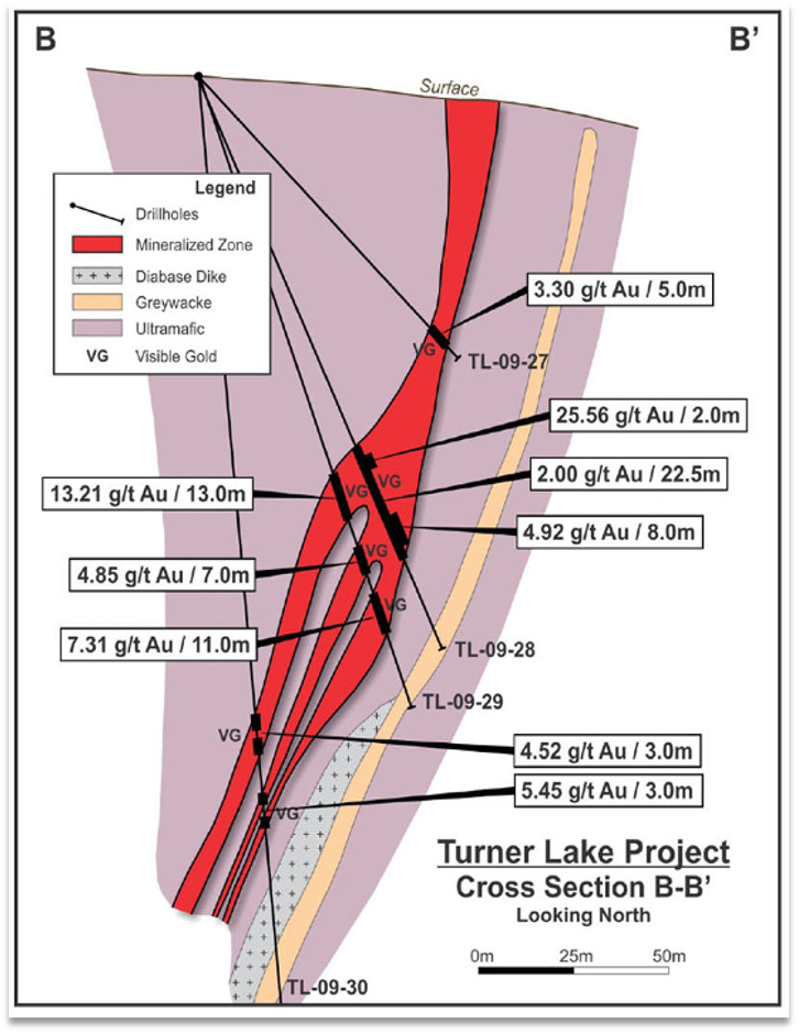
Cross-section showing mineralized zone, visible gold (VG) intercepts, and drill hole geometry.
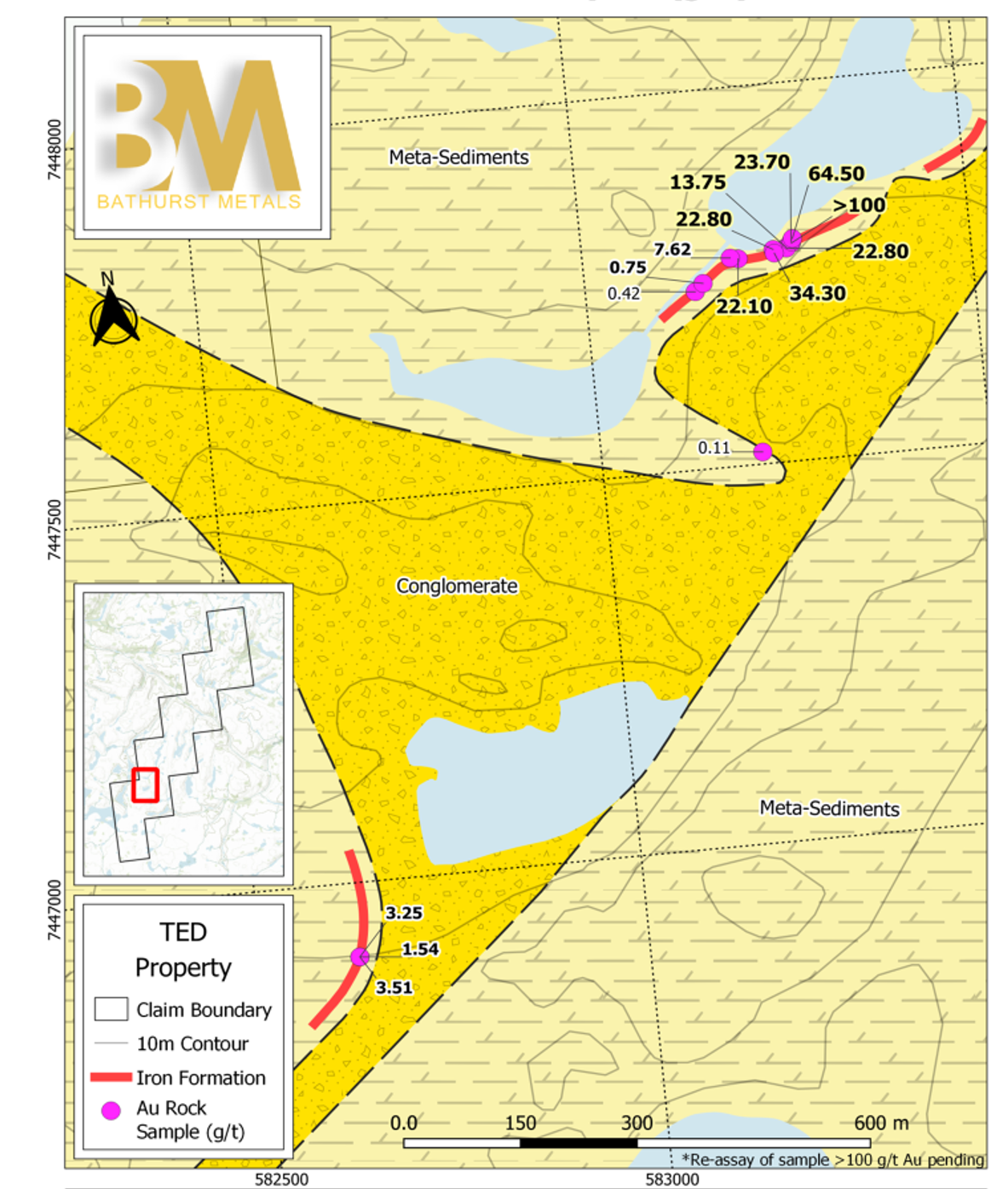
TED Showing
Located 8 km SW of the Turner Lake Main Gold Zone, the TED Showing is an Archean iron formation — geologically analogous to Sabina Gold and Silver. Gold is associated with sulphide-poor to sulphide-rich, chert-rich iron formations, with sulphide-rich lenses hosting pyrite, arsenopyrite, pyrrhotite, and visible gold.
Historic Grab Samples
- ▸ 2021 fieldwork confirmed historic results and visible gold in Archean iron formation
- ▸ 6 of 18 grab samples returned >20 g/t Au (range: 22.8–100 g/t)
- ▸ Area hosting higher-grade values not yet drill tested
- ▸ Geologically analogous to Sabina Gold and Silver iron formation deposits
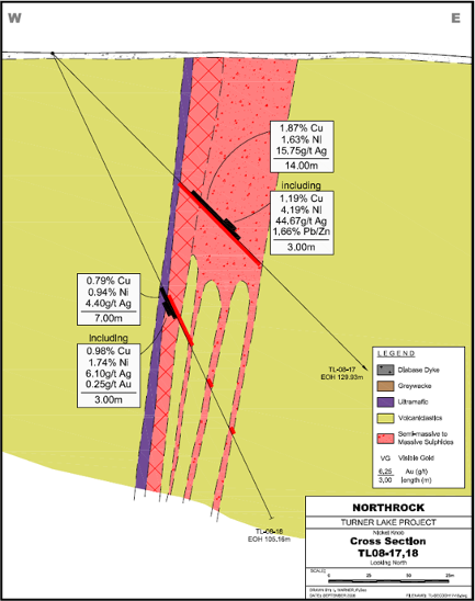
Nickel Knob
A high-grade Ni–Cu–Ag system with polymetallic upside hosted in semi-massive to massive sulphides — comparable to magmatic sulphide systems with scale potential. Mineralization sits within ultramafics and volcanoclastics associated with diabase dykes and greywacke.
Key Intercepts
- ▸ Hosted in semi-massive to massive sulphides
- ▸ Mineralization within ultramafics & volcanoclastics
- ▸ Associated with diabase dykes & greywacke
- ▸ Trace gold present; visible gold noted locally
Disposition · Option Agreement
Muskox Property
Currently under option to SPC Nickel Corp. Generating cash and share proceeds to Bathurst while SPC Nickel advances exploration on the property — a non-dilutive funding source for the Company's flagship work.
Optioned To
SPC Nickel Corp.
Qualified Person
The scientific and technical information on this page has been reviewed and approved by Lorne M. Warner, P.Geo., President and Director of Bathurst Metals Corp., who is a Qualified Person as defined by National Instrument 43-101 – Standards of Disclosure for Mineral Projects. Historical assay results referenced herein are derived from prior work completed by previous operators. The Company has not independently verified these historical results, and they should not be relied upon unless and until verified by Bathurst Metals through future exploration programs.